


Places of Interest
-
Granite outcrops and shady clumps of eucalypt forest around Beacon invite picnickers and campers to explore.
These outcrops are more than 2,500 million years old and comprise part of the Western Shield. - For directions call the Beacon Visitor Centre, on 9686 1014, Monday to Friday.
-
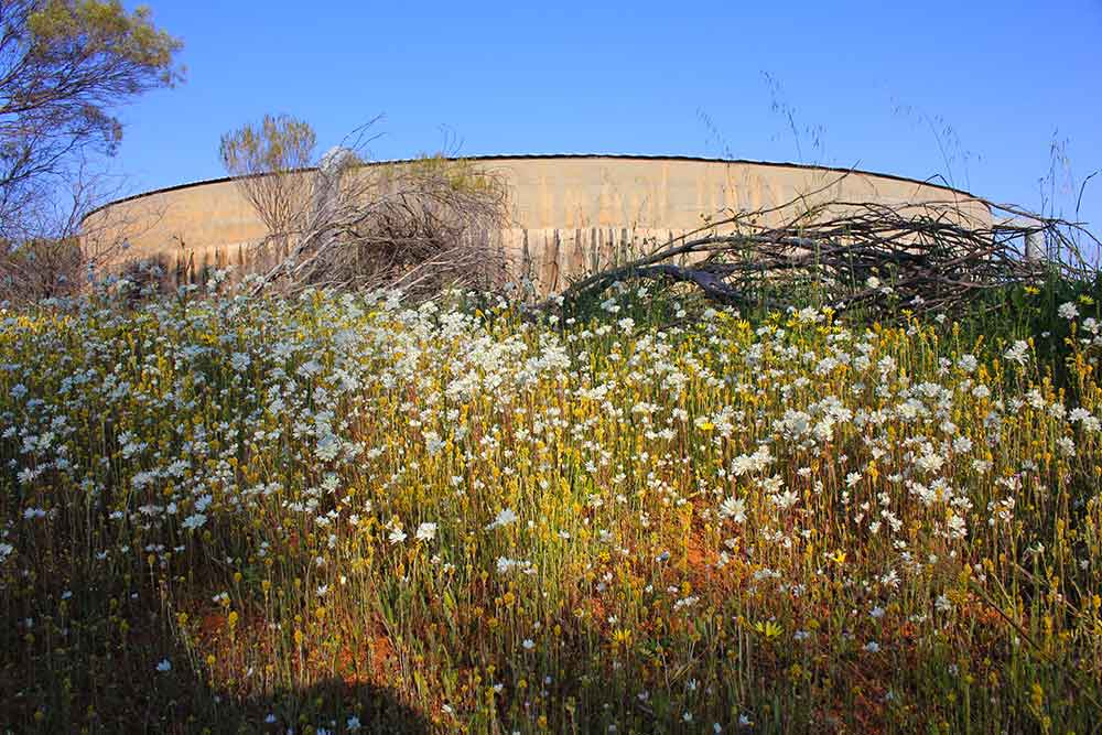
Beacon is the most north-easterly town in the Wheatbelt, adjacent to extensive native bushland and pastoral country.
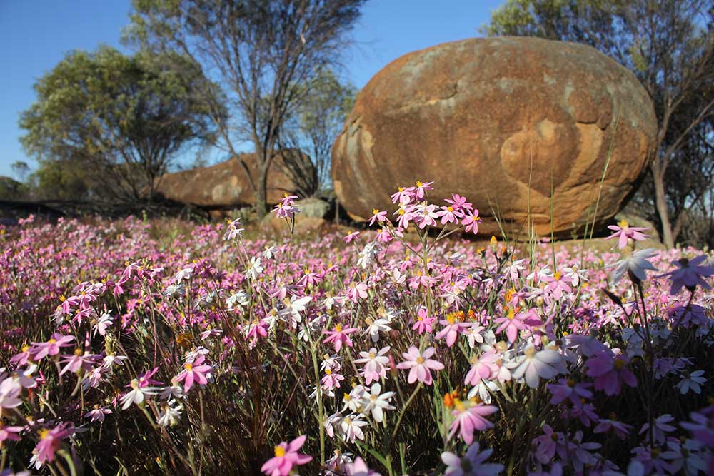
When good seasonal opening rains are experienced the district is set up for a brilliant display of wildflowers from July to October with masses of white, pink & yellow everlastings, about 20 varieties of orchids & many trees and shrubs such as wattles, melaleucas, hakeas, grevilleas, & clematis vines.
* * Beware Baiting Programs carried out in approved areas.

Billiburning Rock **
Surveyed by surveyor, Harry Sanford King around 1889-90, Billiburning Rock is situated in the north-east of the Shire near the vermin proof fence. This rock is part of a large natural forest reserve, a relatively undisturbed bushland area. It has attractive flora and fauna, with the best displays in spring with masses of wildflowers. It’s a pleasant place for a picnic or to camp.
- Billiburning Rock
Billiburning provides fantastic views from the top of both cropping and pastoral country, and also offers many great photographic opportunities. Located on the reserve are a gnamma hole and a soak well which are easily accessible.
Billiburning Reserve is located towards the northern end of the Mt Marshall Shire. The northern end of the reserve backs onto the vermin proof fence which separates Billiburning Reserve from the Karroun Hill Nature Reserve. No motorbikes allowed within the Reserve. Dogs allowed on leash only. Be aware that poison baiting of wild dogs occurs close to this Reserve. To get to Billiburning Rock, take Ingleton Rd north from Beacon townsite for 30 km to the intersection of White Rd & Huckstep Rd. Travel north along White Rd for another 3 km.
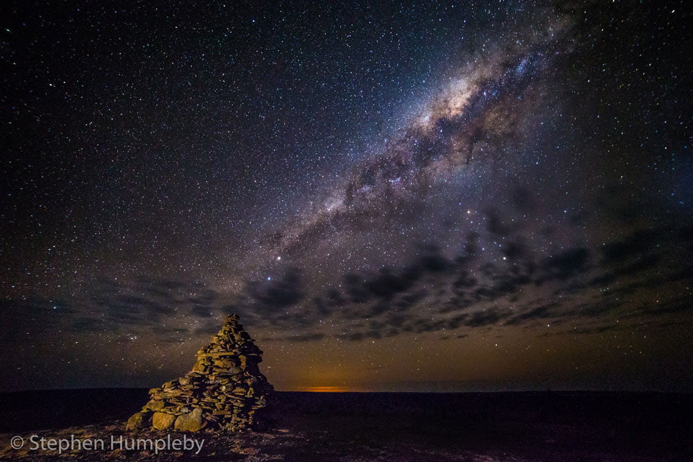
Billiburning Rock
Night Sky time-lapse photo from Billiburning Rock by photographer Stephen Humpleby.
- Billiburning Rock at Night
Night Sky time-lapse photo from Billiburning Rock by photographer Stephen Humpleby.
- Billiburning Rock Video
This great video of Billiburning Rock is from the WA Now and Then Youtube Channel.

Datjoin Well
Travel 18kms east of Beacon on Burakin/Wialki Road to the track entrance to Datjoin Well and camping areas. The track is accessible to cars, 4wds & camper trailers only, no caravans. Camp fires are allowed during April to September. Access to Datjoin Rock is another 2 kms eastwards on Clark Rd on the left. No access to large vans. The track into Datjoin is suitable for 2WD vehicles. Camping is allowed for camper trailers and tents.
- Datjoin Well
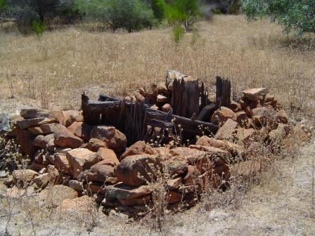
Located 18km east of Beacon is the Datjoin Well and Rock Reserve. The well was dug in early 1900’s by sandalwood cutters.
During the winter and spring months the reserve is a popular picnic destination for picnickers and visitors looking to find some of the best orchids and wildflowers in the district.
Camping is allowed for camper trailers and tents.
Datjoin Rock Reserve
Travel 18kms east of Beacon on Burakin/Wialki Road to the track entrance to Datjoin Well and camping areas. The track is accessible to cars, 4wds & camper trailers only, no caravans. Camp fires are allowed during April to September. Access to Datjoin Rock is another 2 kms eastwards on Clark Rd on the left. No access to large vans. The track into Datjoin is suitable for 2WD vehicles. Camping is allowed for camper trailers and tents.
- Datjoin Rock Reserve
Located 18km east of Beacon is the Datjoin Well and Rock Reserve.
Access to Datjoin Rock is another 2 kms eastwards on Clark Rd on the left.
No access to large vans. The track into Datjoin is suitable for 2WD vehicles. Camping is allowed for camper trailers and tents.
During the winter and spring months the reserve is a popular picnic destination for picnickers and visitors looking to find some of the best orchids and wildflowers in the district.
Tampu Well
- Tampu Well
Located on Bimbijy Rd, about 38 km from Beacon, Tampu Well is an old Government well that was used by shepherds, sandalwooders and prospectors.
The timbered well is in need of some repairs, a gnamma hole can be found by following the north edge of this large granite rock.
It is an excellent wildflower and birdwatching site. Following good winter rainfall, red spider orchids can be seen August – September. Small van access only.

Karroun Hill Nature Reserve
“Paradise On The Edge” excerpts from LANDSCOPE Magazine article by Tony Friend, Senior Research Scientist at CALM Wildlife Research Centre Woodvale WA. The reserve lies at 300–480m above sea level in pastoral farming country. It possesses extensive areas of intact woodland & shrubland lost from much of the adjacent Western Australian wheatbelt through clearing for agriculture. The mulga-eucalypt line crosses the reserve, delineating the boundary between arid wattle-dominated, & temperate eucalypt dominated, botanical regions. The vegetation consists mainly of York and salmon gum woodlands & dense Acacia thickets.
- Karroun Hill Nature Reserve
Karroun Hill Nature Reserve occupies 309,678 hectares in the Mt Marshall Shire, extending from Lake Moore to the rabbit proof fence. The emu-proof fence on its south, lies along the Wheatbelt’s north-eastern limit.
Karroun Hill is the largest (and probably the least widely known) nature reserve in the south west of WA. Here, a rich array of vegetation supports an equally diverse animal wildlife, much of which has escaped the influence of long-established pastoral, agricultural, and gold mining communities that surround it. Karroun Hill Nature Reserve is an extremely valuable asset in WA’s conservation estate.
Poison baiting of wild dogs occurs within this reserve.
Dogs are NOT permitted on Karroun Hill Nature Reserve.
Crimpy's Tank
There are traces of sandalwood cutters tracks on the east and north-east of the rock. This is also a good site for birdwatching.
- Crimpy's Tank
Head west from Beacon for 3 km along Burakin – Wialki Road and turn north onto Bimbijy Road. The turnoff to Crimpy’s Tank is signposted about 25 km from Beacon. With capacity of one million gallons (4.5 million litres) built of reinforced concrete in 1966, Crimpy’s Tank stores rainwater collected by a low rock wall surrounding the nearby granite.
Crimpy’s is a good picnic site and boasts a variety of wildflowers in season.

Wheatbelt Way
Pick up a copy of the FREE 50 page Wheatbelt Way Self Drive Trail Guide Book, which details information on each of the 9 towns from the Beacon Community Resource Centre. The booklet contains sections on each of the 24 interpreted sites including two Audio CDs with dramatised stories to help guide your journey through the north eastern wheatbelt.
- The Wheatbelt Way
The Wheatbelt Way self-drive trail will lead visitors on an adventurous interpreted journey to the regions 9 communities of Dowerin, Wyalkatchem, Koorda, Bencubbin, Beacon, Westonia, Mukinbudin, Nungarin and Trayning. It highlights 24 interpreted sites of the many natural attractions and historical sites while offering you opportunities to stay and experience the unique Wheatbelt communities and landscapes.
Visit The Wheatbelt Way website for more information:
Website: wheatbeltway.com.au/

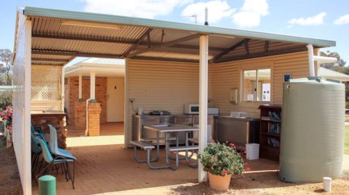
Beacon Botanical Park
The Park entrance is located on Broadbent St, which leads to a parking bay.
- Beacon Botanical Park
The Beacon Botanical Park was established in 1999 as a collaborative project between the Mt Marshall Land Conservation District Committee and the Beacon Primary School.
This park contains several species of native flora that were propagated from local areas.
It is great for a quiet leisurely walk or an opportunity to identify native plants that would suit your own garden.
The Park entrance is located on Broadbent Street, which leads to a parking bay.

Vermin Proof Fence **
** Beware – 1080 Poison Baiting
Only authorised vehicles are permitted to travel along the fence.
- Vermin Proof Fence
The vermin proof fence bisects the Mt Marshall Shire from east to west and marks the south boundary of the Karroun Hill Nature Reserve (300,000 ha). Constructed in the late 1950’s, this fence is important in keeping emus, goats and wild dogs out of farming areas.
State Barrier Fence caution to travellers.
Travellers, sightseers & other members of the public are reminded it is illegal to travel along Western Australia’s State Barrier Fence. People who illegally drive along the fence can face a $10,000 fine.

Mouroubra Rd to Payne's Find Road
This road is an alternative route to and from Perth other and southwest towns for travellers travelling to and returning from their sojourns in the north of that State passing through pastoral country along the eastern side of Lake Moore. The road is unfenced and care should be taken with livestock, kangaroos and emus. Road conditions can be checked by contacting Shire of Mt Marshall (08) 96851202 Mon – Fri.
- Mouroubra Rd to Payne's Find Road
Runs north off the Burakin-Wialki Rd through the sheep station country. It is quite passable except on rare occasions when flooding has occurred. Signs will warn when the road is closed. The road runs through Remlap, Mouroubra and Maranalgo stations and then joins the Great Northern Highway at Paynes Find. When good winter rains are experienced in the north-east Wheatbelt and lower Murchison areas, brilliant displays of wildflowers can be found along Mouroubra Rd. July to October is usually the best time to experience the diverse range of flowers including of masses of white, pink and yellow everlastings.
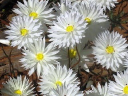
Wildflowers
- Wildflowers
A profusion of wildflowers varies from year to year providing a memorable sight with displays of annuals & everlasting daisies in July to September.
Guided Wildflower Tours
During August and September.
(08) 9686 1014 – Monday to Friday.

Wildlife
- Local Wildlife
Granite outcrops and remnant bushland provide excellent wildlife and bird watching sites.

State Barrier Fence
- State Barrier Fence Caution to Travellers
Travellers, sightseers & other members of the public are reminded it is illegal to travel along Western Australia’s State Barrier Fence; only authorised vehicles are permitted to travel along the fence. People who illegally drive along the fence can face a $10,000 fine.
- Map of Beacon Local Scenic Attractions and Picnic Spots
Map of Beacon Local Scenic Attractions and Picnic Spots

** Beware - 1080 Poison Baiting
The use of traps & 1080 baiting is an integral part of the wild dog management program. Warning signs have been placed at entrances & strategic points on pastoral leases & Crown lands where baiting is undertaken at approved areas. The poison baits will persist for some time & these areas should be considered to contain toxic baits at all times. Licensed Pest Control Operators (‘Doggers’) also use traps treated with strychnine to control wild dogs.
- For further information contact Department of Agriculture and Food: agric.wa.gov.au or Department of Parks and Wildlife.
- ** Beware - 1080 Poison Baiting
Aerial and ground baiting programs (using 1080 meat baits) to control wild dogs is carrried out by the Eastern Wheatbelt Declared Species group on pastoral leases, Department of Parks and Wildlife (DPaW) managed reserves and unallocated Crown Lands within the Eastern Wheatbelt Region.
People are advised to take care and not to allow their pets to enter these areas.
People travelling with domestic pets throughout Western Australia’s pastoral region are reminded to be aware of 1080 baiting and take note of warning signs. Picnic sites and recreational reserves are excluded from baiting programs, however, baiting may take place adjacent to such areas and domestic pets should be kept close and restrained at all times. Dogs are NOT permitted on Nature Reserves.

- ** Western Shield Wildlife Recovery Program
As part of the Western Shield program to bring native animals back from the brink of extinction most parks are baited four or more times a year with 1080. 1080 is found naturally in WA. It does not harm native wildlife, but it is poisonous to introduced predators such as the European red fox and feral cat.
The poison used in baits is based on a naturally occurring toxin in Gastrolobium plants, to which native animals have developed a tolerance. However, it is lethal to introduced animals such as foxes and feral cats, as well as domestic cats and dogs.
These baits are also poisonous to humans. It will kill domestic cats and dogs there is no antidote.
If in doubt about where you can take your dog in our parks, contact the local DPAW office.
More information can be found in their Pet owners beware brochure.
If poisoning occurs, contact a vet or Poisons Information Centre: 131126
or Wheatbelt Veterinary Clinic Emergencies: 0428 671 022